%2C%20with%20neat%20roads%2C%20greenery%20and%20clearly%20marked%20rectangular%20plot%20boundaries.%20Clean%20modern%20professional%20look%2C%20soft%20natural%20daylight%2C%20subtle%20green%20and%20blue%20tones%2C%20depth%20and%20detail.%20Absolutely%20no%20text%2C%20no%20words%2C%20no%20letters%2C%20no%20numbers%2C%20no%20captions%2C%20no%20labels%2C%20no%20signage%2C%20no%20logo%2C%20no%20watermark.?width=1200&height=630&nologo=true&model=flux&seed=2061768711)
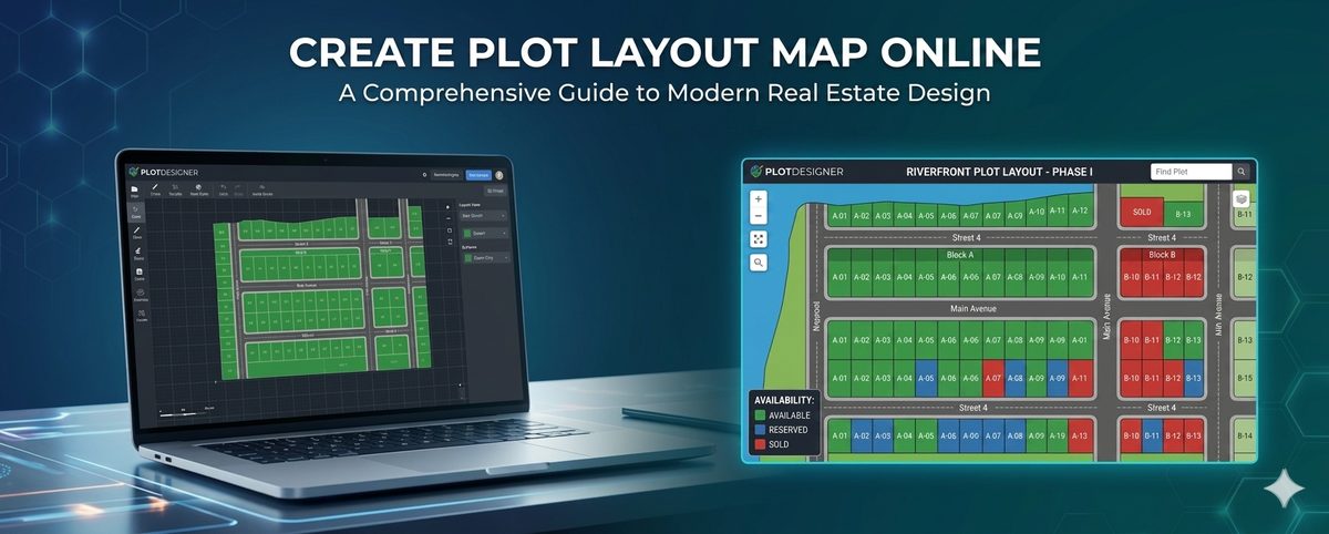
Introduction to plot layout maps is essential for anyone involved in Indian real estate, whether you are a buyer, developer, or investor. A plot layout map is a two-dimensional representation of a land plot, showing its boundaries, dimensions, and other key features. Understanding how to read a plot layout map can help you make informed decisions when buying or developing a plot.
Understanding Key Elements
When reading a plot layout map, it is crucial to understand the key elements that are typically included. These elements may vary depending on the location and the purpose of the map, but some common features include the plot's dimensions, orientation, boundary lines, adjacent plots, roads, and other notable features such as water bodies or landmarks.
Plot Dimensions and Orientation
The plot's dimensions are usually indicated in meters or feet, and the orientation is shown using a north arrow. Understanding the plot's dimensions and orientation is vital for planning construction projects and ensuring that the plot is suitable for your needs.
Land Measurement Units in India
In India, land is typically measured in units such as square meters, square feet, or acres. One acre is equal to 4046.86 square meters, and it is essential to understand these units when reading a plot layout map. Additionally, it is crucial to be aware of the conversion factors between different units to avoid errors.
Identifying Boundaries and Adjacent Plots
The plot's boundaries are usually indicated by a thick line, and adjacent plots are shown using thinner lines. It is essential to identify the boundaries and adjacent plots to understand the plot's layout and potential. Additionally, it is crucial to check for any encroachments or boundary disputes that may affect the plot's value or usability.
Notable Features and Roads
Notable features such as water bodies, landmarks, or easements are usually indicated on the plot layout map. Roads and other infrastructure are also shown, and it is essential to understand how these features may impact the plot's accessibility and value.
Using a 3D Plot View
A 3D plot view can be extremely helpful in visualizing the plot's layout and understanding its dimensions and boundaries. By using a 3D plot view, such as the one provided by Plotex, you can easily identify potential issues and plan your construction projects more effectively.
| Unit | Conversion Factor |
|---|---|
| Square Meter | 1 square meter = 10.76 square feet |
| Square Foot | 1 square foot = 0.0929 square meters |
| Acre | 1 acre = 4046.86 square meters |
Common Mistakes to Avoid
When reading a plot layout map, there are several common mistakes to avoid. These include misinterpreting the plot's dimensions, failing to identify adjacent plots or notable features, and not understanding the conversion factors between different units. By being aware of these potential mistakes, you can ensure that you make informed decisions when buying or developing a plot.
Conclusion
Understanding how to read a plot layout map is a crucial skill for anyone involved in Indian real estate. By knowing how to identify key elements, understand land measurement units, and use a 3D plot view, you can make informed decisions and avoid potential pitfalls. Whether you are a buyer, developer, or investor, taking the time to learn how to read a plot layout map can help you achieve your goals and succeed in the Indian real estate market.
Frequently Asked Questions
What is a plot layout map?
A plot layout map is a visual representation of a land plot, showing its boundaries, dimensions, and other key features, helping buyers and developers understand the plot's layout and potential.
What are the key elements of a plot layout map?
Key elements include the plot's dimensions, orientation, boundary lines, adjacent plots, roads, and other notable features, all of which are crucial for understanding the plot's layout and potential.
How do I measure land in India?
In India, land is typically measured in units such as square meters, square feet, or acres, with one acre equal to 4046.86 square meters, and it is essential to understand these units when reading a plot layout map.
What is the importance of understanding plot layout maps?
Understanding plot layout maps is vital for making informed decisions when buying or developing a plot, as it helps identify potential issues, such as encroachments or boundary disputes, and enables buyers to plan their construction projects effectively.
Can a 3D plot view help in understanding plot layout maps?
Yes, a 3D plot view, such as the one provided by Plotex, can be extremely helpful in visualizing the plot's layout and understanding its dimensions and boundaries, making it easier to identify potential issues and plan construction projects.