If you've ever stared at a land plot map and felt lost, you're not alone. Plot maps pack a lot of information into lines and numbers. This beginner's guide explains the parts of a land plot map in plain language, so you can read any layout with confidence before buying.
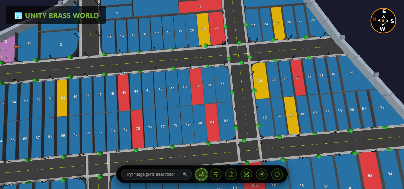
The key elements of a land plot map
| Element | What it tells you |
|---|---|
| Plot boundaries | The exact outline and shape of each plot |
| Dimensions | The length of each side (e.g., 30 × 40 ft) |
| Plot number | The unique ID used in documents and brochures |
| North arrow | Orientation — essential for facing and Vastu |
| Roads | Access, road width and which plots are corner plots |
| Survey / Gat number | The legal land reference for verification |
| Amenities/open space | Parks, common areas and reserved land |
1. Start with the north arrow
Find the north arrow first. It tells you each plot's facing (east-facing, north-facing, etc.), which affects sunlight, Vastu preference and often price.
2. Read the plot dimensions
Dimensions are written along each side. A plot marked 30 × 40 means 30 feet on one pair of sides and 40 on the other — multiply for area (1,200 sq.ft). Check that the dimensions match the area stated in the documents.
3. Identify roads and corner plots
Lines between plots are roads; their width is usually labelled. Plots touching two roads are corner plots — often pricier due to better access and light.
4. Note the survey/gat number
This is the legal reference for the land. You'll use it to verify ownership and approvals in government records, so always cross-check it against the sale documents. For the full process, see our guide on how to verify a plot before buying.
5. Check reserved and open spaces
Approved layouts reserve land for roads, parks and amenities. Make sure the plot you want isn't on reserved or disputed land.
Why 3D plot maps are easier to read
Traditional 2D plot maps require this kind of interpretation. A 3D plot map shows the same information visually — you see facing, roads and plot position directly, which is why more developers now share interactive 3D layouts. Compare the two in digital vs traditional maps, or explore a 3D plot viewer to see how a layout reads when it's interactive.
Frequently asked questions
What does 30x40 mean on a plot map?
It means the plot is 30 feet by 40 feet, giving an area of 1,200 square feet. Always confirm it matches the area in the legal documents.
How do I find a plot's facing?
Use the north arrow on the map. The direction the plot's main road-facing side points to is its facing (e.g., east-facing).
What is a survey or gat number?
It's the official land reference used in government records to identify and verify the parcel of land.
Prefer a map you don't have to decode? Explore plots in interactive 3D with Plotex.