You already have a layout — it's just stuck inside a PDF or CAD file that buyers can't really use. Converting that PDF map to a 3D plot visualization turns a flat document into an interactive site plan buyers explore on any phone. Here's exactly what the conversion involves and how to do it.
What "converting a PDF to 3D" actually means
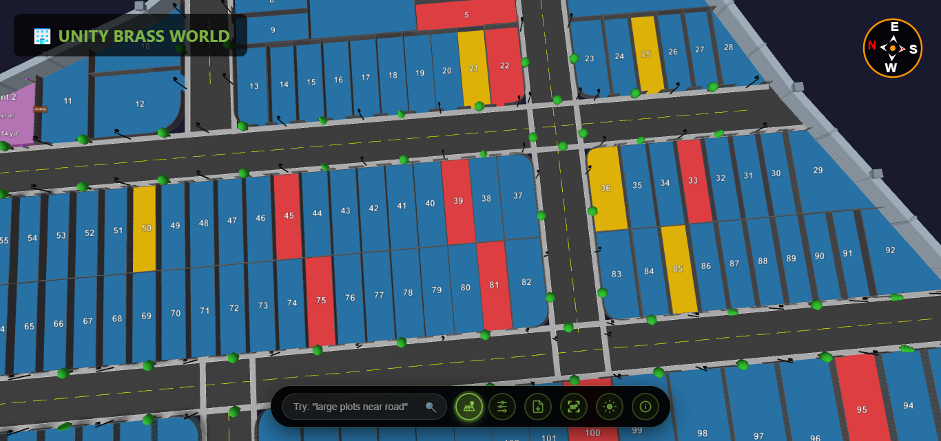
It doesn't mean redrawing your project from scratch. The conversion takes the geometry in your existing PDF/CAD layout — plot boundaries, numbers and roads — and rebuilds it as a 3D, clickable model with real plot data attached to each plot. The result behaves like an 3D plot viewer: buyers rotate, zoom and click any plot, instead of squinting at a static image.
What you need to convert
- Your source file — a PDF, CAD/DWG, or a clear scanned survey drawing.
- Plot details — numbers, sizes, prices, facing and availability.
- A 3D plot platform such as Plotex (browser-based; nothing to install). It doubles as your plot layout software, so the same upload becomes a buyer-ready interactive plan.
The conversion process, step by step
- Upload the PDF/CAD. It becomes the base reference for the model.
- Map the plots. Each plot boundary becomes an individual, clickable element.
- Attach data. Add size, price, facing and status to every plot.
- Add depth & context. Roads, terrain and amenities are represented in 3D.
- Publish a link. Share the interactive visualization anywhere.
If you don't have a finished layout yet, you can also create a plot layout map online from your survey data and skip straight to the interactive result.
Before vs after
| PDF map | 3D plot visualization | |
|---|---|---|
| Interactivity | None (static) | Click, zoom, rotate each plot |
| On mobile | Pinch a tiny PDF | Smooth browser experience |
| Availability | Fixed when exported | Live status updates |
| Sharing | File download | One link |
For a deeper side-by-side on each factor, see our full comparison of 3D plot view vs PDF maps.
How long does conversion take?
For a typical layout, conversion is measured in hours to a couple of days depending on plot count — far faster than recreating the project, because your existing file does the heavy lifting.
Frequently asked questions
Can any PDF map be converted to 3D?
If the PDF clearly shows plot boundaries and dimensions, yes. A vector PDF or CAD file gives the cleanest result; even a good scan can be used as a reference.
Will the 3D version match my approved layout?
Yes — it's built from your existing geometry, so plot numbers and boundaries stay consistent with the approved layout.
Do I lose my original PDF?
No. The 3D visualization is an additional, buyer-facing asset; your original file stays exactly as it is.